Landscape
design research is important for cultivating spatial intelligence in landscape
architecture. This study explores GIS (geographic information systems) as a
tool for landscape design research – investigating landscape designs to
understand them as architectonic compositions (architectonic plan analysis).
The concept ‘composition’ refers to a conceivable arrangement, an architectural
expression of a mental construct that is legible and open to interpretation.
Landscape architectonic compositions and their representations embody a great
wealth of design knowledge as objects of our material culture and reflect the
possible treatment of the ground, space, image and program as a characteristic
coherence. By exploring landscape architectonic compositions with GIS, design
researchers can acquire design knowledge that can be used in the creation and
refinement of a design. The research aims to identify and illustrate the
potential role of GIS as a tool in landscape design research, so as to provide
insight into the possibilities and limitations of using GIS in this capacity.
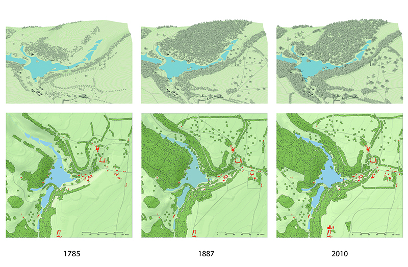
Reconstruction of the development of Stourhead landscape garden (Wiltshire, UK) with GIS (image: S. Nijhuis, TU Delft)
GIS-based design research has the possibility to cultivate spatial intelligence in landscape architecture through three fields of operation:
- GIS-based
modelling: description of existing and future landscape architectonic
compositions in digital form;
- GIS-based
analysis: exploration, analysis and synthesis of landscape architectonic
compositions in order to reveal latent architectonic relationships, while
utilizing the processing capacities and possibilities of computers for ex-ante
and ex-post simulation and evaluation;
- GIS-based visual representation: representation of (virtual) landscape architectonic compositions in space and time, in order to retrieve and communicate information and knowledge of the landscape design.
Analysing visual properties with GIS. Minkowsky model of Piazza San Marco (Venice, Italy) (image: S. Nijhuis, TU Delft)
GIS can be regarded an external cognitive tool that facilitates and mediates in design knowledge acquisition. GIS facilitates in the sense that it can address the ‘same types of design-knowledge’ regarding the basic, spatial, symbolic and programmatic form, but in a more precise, systematic, transparent, and quantified manner. GIS mediates in the sense that it influences what and how aspects of the composition can be understood and therefore enables design researchers to generate ‘new types of design-knowledge’ by advanced spatial analysis and the possibility of linking or integrating other information layers, fields of science and data sources.
The research contributes to the development and distribution of knowledge of GIS-applications in landscape architecture in two ways: (1) by ‘following’ the discipline and developing aspects of it, and (2) by setting in motion fundamental developments in the field, providing alternative readings of landscape architecture designs.
Further reading
To download:- Nijhuis, S (2015) GIS-based landscape design research. Stourhead landscape garden as a case study. Delft: A+BE http://dx.doi.org/10.7480/abe.2015.13
-
Nijhuis, S. (2013) ‘New Tools. Digital media in landscape architecture’, in: Vlug, J. et al. (eds.) The need for design. Exploring Dutch landscape architecture. Velp, Van Hall Larenstein, University of Applied Sciences, 86-97 https://www.researchgate.net/publication/287331117_New_Tools_Digital_media_in_landscape_architecture
-
Nijhuis, S (2014) ‘GIS-based landscape design research: Exploring aspects of visibility in landscape architectonic compositions’, in: Lee, DJ, Dias, E & Scholten, H (eds.), Geodesign by Integrating Design and Geospatial Sciences, GeoJournal Library 111, 193-217. Heidelberg: Springer Verlag. http://dx.doi.org/10.1007/978-3-319-08299-8_13
-
Nijhuis, S (2016) GIS-toepassingen in onderzoek naar buitenplaatsenlandschappen. Bulletin KNOB, 3; 149-166. http://dx.doi.org/10.7480/knob.115.2016.3.1404
-
Nijhuis, S (2016) Applications of GIS in landscape design research. Research In Urbanism Series, 4(1), 43-56. http://dx.doi.org/10.7480/rius.4.1367
- Nijhuis, S, Zlatanova, S, Van der Spek, S, Hoeven, FD van der & Dias, E (eds.) (2016) Geo-Design. Advances in bridging geo-information technology, urban planning and landscape architecture. TU Delft Open (ISBN 978-94-92516-42-8) https://doi.org/10.7480/rius.4